|
 Geomorphology Geomorphology
Sundarban delta the most active and dynamic
river basin has been formed from sediments washed down from
Himalayas. But the process of periodic flooding, alluvion
and diluvion changed the course of innumerable waterways that
has criss-crossed the lower delta and made it near impossible
task for any geographer to define the area under definite
latitude, longitude and other logistic measurements and to
make a correct map of the area. This can be explained by a
single fact that not even 2000 years ago the river mouth of
the Ganga was far inside, say, about 200 miles (322 km) than
what it is today. Ptolemy in 150 AD probably the earliest
geographer to map this area and indicated five mouths of river
Ganga, such as Kambyson, Mega, Kamberikhon, Pseudostomon and
Antibole. The western most Kambyson is recognised as Sagar
Island of today. The definite position of other four places
are yet to be ascertained (Mandal and Ghosh, 1989).
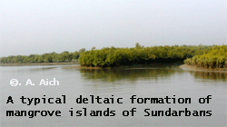
Altitude of Sundarbans ranges from sea level
to 10m at the most. The broad belt of the entire Sundarbans
mangrove extends for about 480 km along the coast and characterizes
the most spectacular environment unit of the area. In transverse
profile- from the mainland to the sea- the important geomorphic
units of the Sundarbans delta include (1) distributary channels
with lag, sub- aerial and sub-aqueous levees, splays and tidal
flats, (2) marginal marshy areas above mean tide level, (3)
tidal sand bars and islands with their network of tidal channels,
(4) sub-aqueous distal bars, and (5) pro-delta clays and silts.
The coastal processes are influenced by a
combination of interesting factors, comprising wave parameters,
micro and macro- tidal cycles, and longshore currents found
in the coastal tract of the Sundarbans, which vary during
the pre-monsoon, monsoon and post-monsoon periods. They are
also affected by tropical cyclones (Chaudhuri and Choudhury,
1994).
The Sundarbans, covering some 10,000 sq.
km of mangrove forest and water ( 40% of which is in India
and the rest in Bangladesh), is part of the world's largest
delta (80,000 sq. km) formed from sediments deposited by three
great rivers, the Ganges, Brahmaputra and Meghna, which converge
on the Bengal Basin.
The whole Sundarbans area is intersected
by an intricate network of interconnecting waterways, of which
the larger channels are often a mile or more in width and
run in a north-south direction. These waterways, apart from
the Baleswar River on the eastern edge of the Bangladesh Sundarbans,
now carry little freshwater as they are mostly cut off from
the Ganges, the outflow of which has shifted from the Hooghly-Bhagirathi
channels progressively eastwards since the seventeenth century
(Seidensticker and Hai, 1983). This is due to subsidence of
the Bengal Basin and a gradual eastward tilting of the overlying
crust.
In the Indian Sundarbans, the western portion
receives some freshwater through the Bhagirathi-Hooghly river
system but that portion designated as the tiger reserve is
essentially land-locked, its rivers having become almost completely
cut off from the main freshwater sources over the last 600
years (Sanyal and Bal, 1986). Thus, waterways in the tiger
reserve are maintained largely by the diurnal tidal flow,
the average rise and fall being about 2.15m on the coast and
up to 5.68m on Sagar Island (Lahiri, 1973).
Tidal waves are a regular phenomenon and
may be up to 75m high. The land is constantly being changed,
moulded and shaped by the action of the tides, with erosion
processes more prominent along estuaries and deposition processes
along the banks of inner estuarine waterways influenced by
the accelerated discharge of silt from seawater (Sanyal and
Bal, 1986).

About half of the Sundarbans is under water
(Lahiri, 1973) and the rest of the landscape is characterised
by low-lying alluvial islands and mudbanks, with sandy beaches
and dunes along the coast. As with the rest of the Bengal
Plain, alluvial deposits are geologically very recent and
deep, sediment of just the last few million years being as
much as 1,000m thick (Seidensticker and Hai, 1983). The subsoil
consists of alternate layers of clay and sand, gradually changing
into shales and sandstone. The soil is clayey loam down to
a depth of 1.1-1.4m and thereafter stiff black clay. It is
alkaline due to an excess of sodium chloride (Lahiri, 1973).
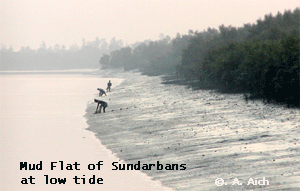
Based upon geomorphological features the
intertidal foreshore zones may be differentiated into 3 categories
(Chaudhuri and Choudhury, 1994), namely (1) the estuarine
intertidal region, (2) the mixed intertidal region, (3) the
open sea intertidal region.
1.) The western shoreline of sagar Island,
to the West of Harinbari and Mandirtala, shows features typical
of the estuarine intertidal zone. The section of the estuary
is subject to a marked tidal influence, being situated at
the mouth of the Hooghly wave action is insignificant in this
portion of the intertidal region because of the presence of
suspended sediment in the river , the shallow depth of the
river bed, and the presence of many tidal creeks and mangrove
root systems. Marked tidal rhythm in the order of five meters
have produced extensive tidal flats with silt deposits.
2.) The coastal area to the east & west
of Gangasagar, situated on the southern margin of Sagar Island,
is representative of the mixed intertidal zone. This zone
is subjected to freshwater discharge from the Hoogly river
together with tidal action found throughout the Bay of Bengal.
3.) The Sand flats of lower long sands are
example of the open sea intertidal zone, being located at
the southernmost extremity of the deltaic system.
A variety of habitats are found in the Sundarbans including
beaches, estuaries, mangrove swamps, tidal flats and tidal
creeks, coastal dunes and back dune areas. The mangrove vegetation
of the intertidal environment assists in the creation of new
landmass and the intertidal vegetation has an important role
in swamp morphology. The activities of mangrove fauna in the
intertidal mudflats, mangrove substrate and beaches, develop
micro-morphological features which are very significant for
trapping sediments and mangrove seeds. The morphology and
evolution of the eolian dunes are controlled by an abundance
of xerophytic vegetation. Creepers and grassy vegetation play
an important role in stabilizing sand dunes (Bhattacharya
and Choudhury, 1987).
|